
The Western Arthur range has got to be one of the most dramatic, rugged, isolated and challenging of all the tracked ranges in Tasmania, and (as I’m sure is true for most avid bushwalkers) has been high on my ‘list of things to do’ ever since I heard of it and set eyes on it.

Interestingly enough, just over two years ago I climbed my very first mountain, Scotts Peak, which lies in the middle of Lake Pedder with views towards the Western Arthurs. At the time I didn’t know the significance of that walk, the friendships it would result in, or what I was looking at. All I knew was that I loved sitting on the top of that mountain, surrounded by still blue water the colour of the sky and so many mountains, on a brilliant summers day.
And as I did more walking, the mountains I’d seen were given names, and reputations to go with them, and then I heard about the Western Arthurs. I knew I was going. One day.
Then at this time last year I was invited on my first serious multiday walk to the Frankland Range (yes, I tend to jump straight into things, and was very lucky and grateful for the invite!). I fell in love all over again with mountains.. in a new and different way that comes with traversing a range, rather than just climbing individual mountains. It was on that walk that I decided ‘one day’ was here. Well, in a year’s time.

Having just started a new job time off was an issue so it was going to have to wait to this year. A year of impatient anticipation and planning, and then all of a sudden it was on us, and more than the usual amount of nervous excitement took over, perhaps for the first time the nervousness outweighing the excitement? It was the biggest trip either myself or Shaz had done (we were planning 12 days to allow for weather, Graham was going to join us and walk as far as he could for 9 of those days), neither of us knew how we’d go with the weight, how we’d find the steep, climby or challenging sections, how the weather would treat us, whether we’d be free from injury, whether we’d succeed or not. It didn’t help that we had no real marker of success (more on this later).

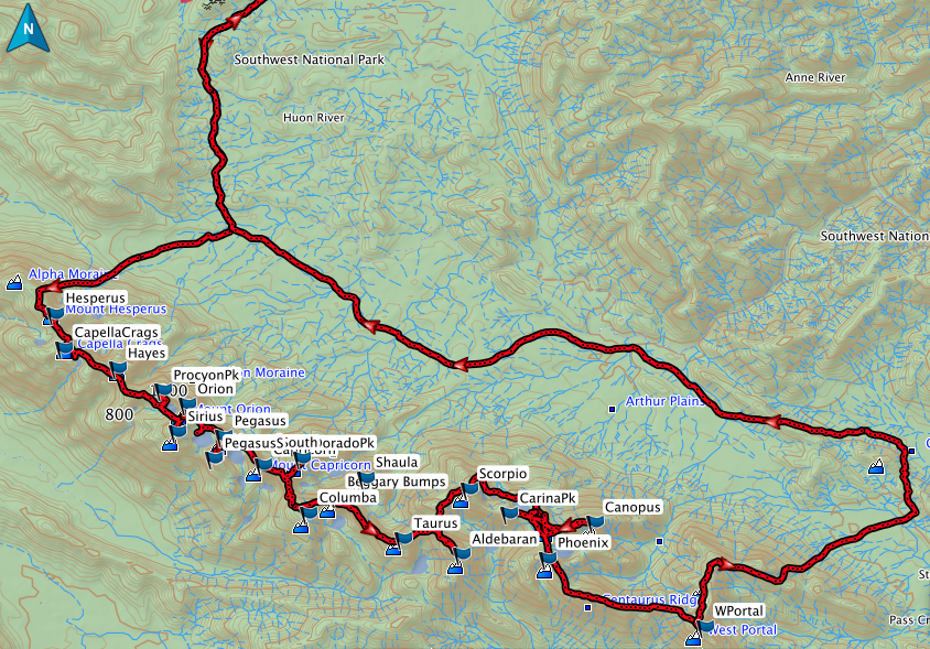
But one of the things you learn quite early on with bushwalking is that you just put your head down and do what needs to be done in the face of a challenge, despite nerves, fears or doubts, and see what comes of it before reassessing. So, relatively happy with the initial weather forecast, off we went, one step at a time (and there must have been a lot, my GPS says we walked over 115km, with 7870m ascent).
Day 1: Car park to Lake Cygnus (Hesparus and Capella Crags)

I had done my usual overnight shift from 9pm Friday to 5am Saturday morning, raced home for a shower, and got a lift with Graham to Granton, where I jumped into Shaz’s car. We chatted a bit on the drive, feasting on cherries, raspberries and peaches generously picked freshly from Graham’s garden (enjoyed even more with the knowledge that it would be the last fresh fruit we’d see for over a week). But as we approached Scotts Peak road we grew quiet, and despite my excitement I found it harder and harder to keep my eyes open. I drifted in and out until just after Mt Anne, and was then wide awake. Everything felt so very different from a normal walk, it didn’t feel real, the range felt so far away, and it was VERY weird to be looking at mountains and not knowing a single one of them. It was quite disconcerting actually, and was doing well to keep what would have been an excessive amount of excitement in check.

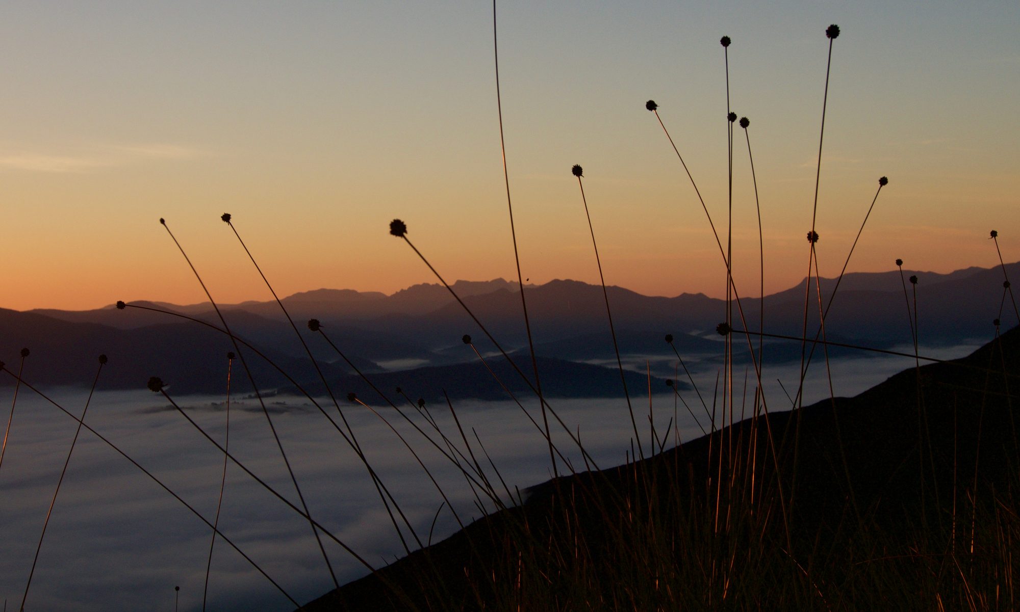
The weather seemed to reflect this. Showers were forecast, and though you could see the whole range stretching mightily along the horizon as you drove along the last section of road, the tops of the higher peaks were covered by dark cloud, and most of the range was in shadow. In some places this cloud looked menacing, but if you shifted your attention slightly to the left or right, you’d see where the cloud was broken, revealing blue sky and white fluffy tops to the grey bottoms, allowing patches of sunlight through to light up spots on the flanks of the range. It seemed fitting, perfect in the contrasts, the uncertainties, and I smiled. What would be, would be, and it would be right. Anxiety over pack weights and keeping up with Graham waned, and disappeared entirely as I took my first few steps.

The ‘whole’ was suddenly cast aside, and all there was was today’s walking, which was further split up into manageable sections, to Junction Creek, to Alpha Moraine, to the Ridge, Hesparus, Capella Crags, and finally, Lake Cygnus. And this was how it would be till we got back to the cars. The tireder I got, the smaller the sections I divided things into in my head (up the next climb, down to the next saddle, round the next bump). The whole was just too much to take in in one go, and the nature of the range meant plans had to be flexible and indeed, they changed on a day-to-day basis. And maybe that’s why it’s hard to put it all back together now and feel like we’ve actually done the full traverse. Though it’s slowly sinking in.. slowly!

My pack was heavy, and I was moving slower than usual, but once into the rhythm I was feeling ok, and started to think 12 days were manageable. We headed through forest, then out over the open plains, winding our way between and around small rises that obscured and then revealed glimpses of our mountains. At each new revelation we shared smiles, and I knew I was where I belonged, where I am at home, and that the following days were going to be ok. I wondered what secrets the mountains I was looking up at held, what experiences and memories they’d create, but for once, I wasn’t impatient to find out, I was more than happy to savour each moment as it came. The squawking of black cockatoos brought me out of my thoughts, and I listened as Shaz and Graham remembered the cockatoos the last time they were walking the track, during their ill-fated attempt to get to Federation Peak.

A little while later who should we run into but Marc and Greg, two friends and Pandani members. It was great to see them, have a bit of a chat about what they’d done and how it had been, and learn about the hungry mice at Cygnus. They’re both really decent guys. Greg might tease, but he’s caring underneath and is always there to help those who need or want it. Marc is gutsy. He’s got muscular dystrophy, but that doesn’t define or limit his vision. Every time I greet him with a hug his bony frame, which is remarkably well hidden by baggy clothes, shocks me, and I hope he’s doing ok, but his upbeat and determined outlook on life means there’s no feeling sorry for him, just a lot of respect. Plenty of people with no physical disability would question whether they could or should attempt the Western Arthurs, and maybe Marc did too, but the answer was a definite yes. And that, I think, is the battle won. All he needed then was a good friend, and the humbleness and willingness to ask for, and accept, help. I reflected on this in the middle of the trip in response to another friend’s questioning of the difficulty of the ascents/descents, and again towards the end of the trip in reflection of my own reluctance to ask for pain medication/strapping for a rolled ankle (because I hadn’t brought anything strong, or learnt how to strap an ankle, and therefore should just grin and bare it). And again, I shook my head at how inspirational Marc continues to be, and also decided I would try to take a leaf out of his book.
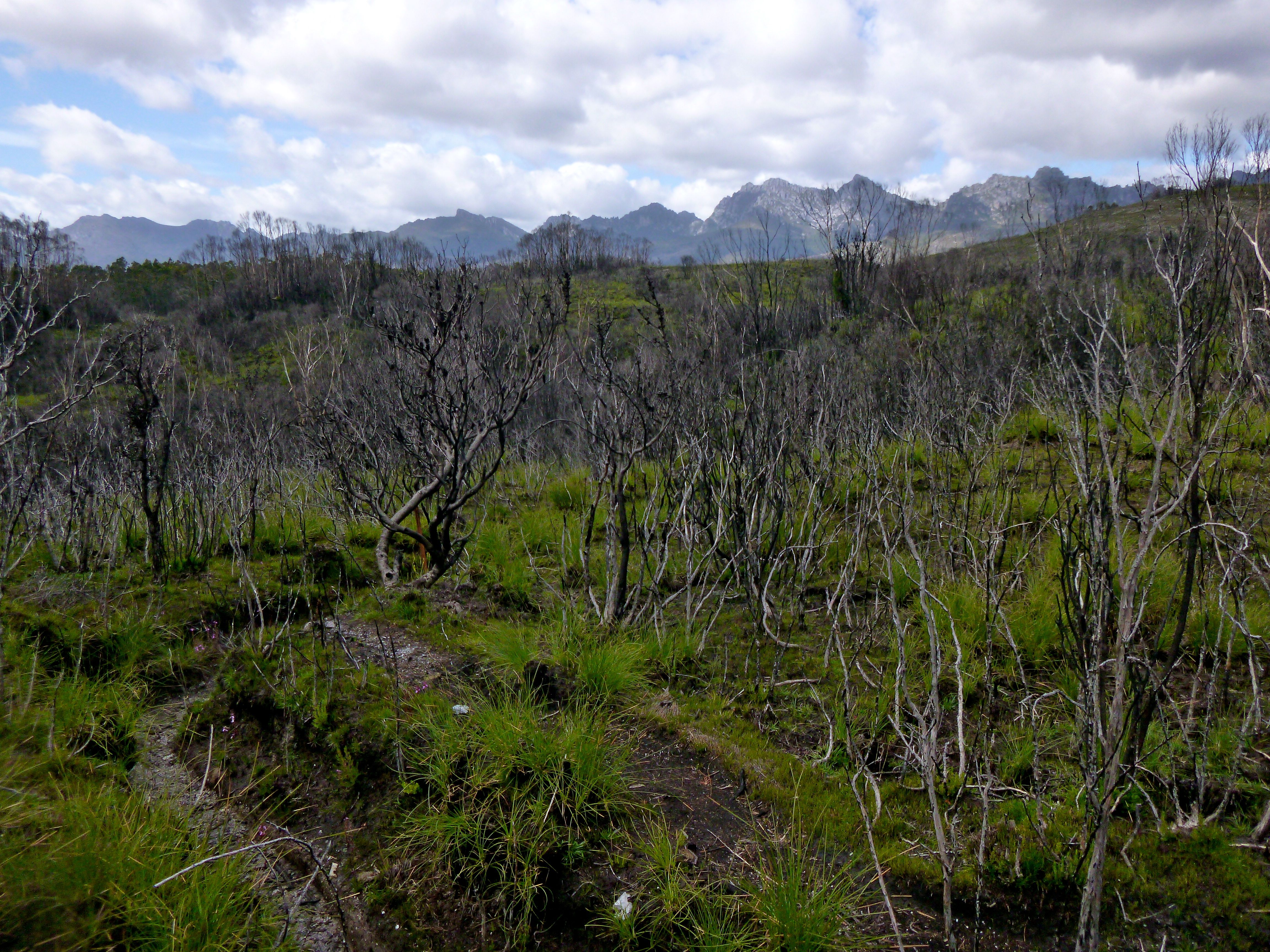
 As we approached Junction Creek the extent of the bushfires was clear, and quite shocking, especially I imagine for Shaz and Graham, both of who had been in before. It’s such a different feel walking through black and grey skeletons of burnt out trees and scrub, that claw at you with bony fingers, juxtaposed with the brilliant emerald green of new growth and life, which was further lit up by the blues, yellows, whites and purples of small happy flowers. The image of life and death, side by side, was beautiful but was also confronting. And there was something unsettling that I couldn’t quite put a finger on, despite knowing fire is a part of the cycle of life out in the wild, and that the Aborigines most likely routinely burnt out these very plains.

We ate our first lunch at Junction Creek, Shaz receiving the first injury for the trip as a foot slipped on the wet steps down to the river, and she landed on her coccyx. Every step up, and every misstep, would prove to be a lot more painful for her than the rest of us for the next 8 days. I indulged on cherry tomatoes to reduce a bit of weight before the climb ahead (that was my reasoning anyway).

When deciding 12 days worth of food wasn’t too bad to carry, I’d overlooked the fact that I hadn’t actually started to climb yet, and heading up Moraine A I’m not sure I still felt that way. I know Shaz didn’t, but she’s lighter than me at 58kg, and her pack is just shy of half her body weight. Graham strode ahead on the plain, then bounced up the ascent, looking like he had nothing in his pack, I plodded along a distance back, and Shaz brought up the rear. Again, as I looked at them both, and took photos to remember the moment, I knew I was so very lucky to be in a place I loved, doing something I loved, with people I loved. I smiled, then laughed, and said a quiet thank you.

Then it was head down, blinkers on, and all energy went into propelling me and my gear upwards. I stoped each time I reached Graham, who had either stopped to take photos, wait for us to catch up, or both. We switched the lead around later, sometimes walking together, most times we were some distance apart, but there was a tie that bound us despite our individual journeys, and pausing for breath on a rock chosen usually for its vantage point, we’d send smiles that said what words couldn’t (both because of the distance, and because there were no words for what we were experiencing – it would be like this for the whole trip).

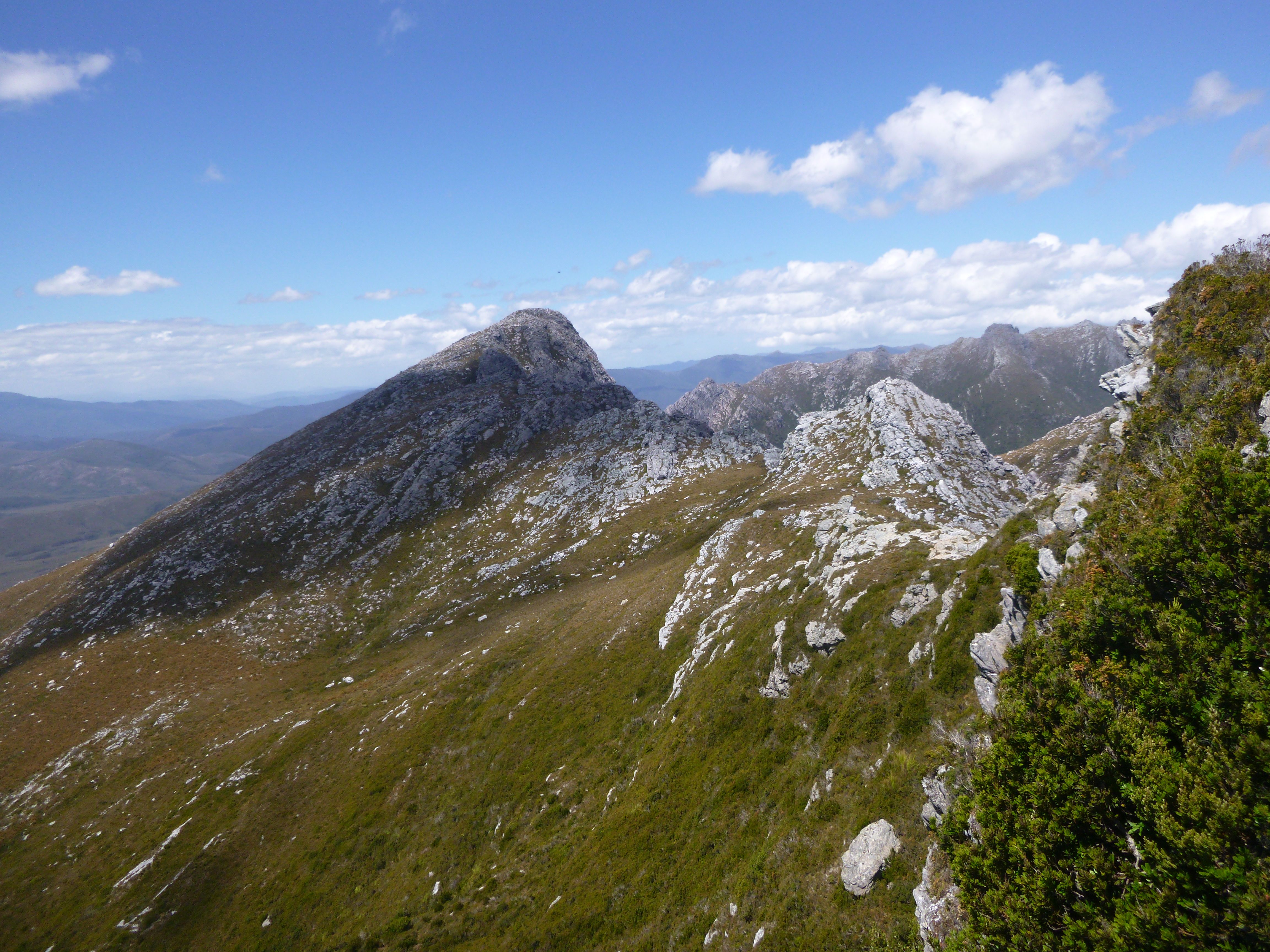
I was grateful for these stops, as it gave me time to take in the view and marvel. The rocks were beautiful, sculpted by earth’s forces; the ranges around majestic, some covered in cloud, some clear, some in rain, changing moods with the weather. It was beautiful to witness; the power of nature humbling. We were all too aware of how it would shape our experience of the Western Arthurs, as it does everyone’s. But on this account, we were to be very very lucky.

On top of the ridge, we expressed our joy and relief at having done the hard work for the day, and then plunged straight into enjoying the reward, running to nearby rocks on the rim to take in the view. Graham and I somehow ended up on a rocky rock and proceed to a) see how far it would rock, b) see how far we were willing to let it rock, and c) see who would be scared off first (maybe that was just me though!).

My attention was drawn to what lay ahead, and again experienced that weird and new feeling of knowing I’d be intending on traversing the range ahead, and climb most of the peaks I could see, but not actually knowing what was what. But I set that aside, I’d find out eventually. For now, a cartwheel was definitely in order! I was excited about the days ahead, there was no suppressing it anymore.
The wind was cold, and the weather was starting to threaten to settle in (we were expecting rain, it had just been awfully good to hold off for so long), so we stayed only as long as we felt we deserved. There was just a small distance to walk, two nearby mountains to climb (Hesparus and Capella Crags), and a drop into lake Cygnus where we’d spend the night.

So we headed along the track, dropping our packs at a spot we thought was the best place to head left up Hesparus, and sure enough, there was a pad. We were working on the understanding that there was a pad up everything that wasn’t on the track, except for Shaula, and it was reassuring to start off with one (the understanding proved pretty accurate). A very short walk, one that didn’t quite feel right for a mountain, and we were on the summit. I had my first views from a peak on the range I had wanted to traverse for over a year, it was not a feeling easily forgotten. I doubt I’d ever tire of the views around us, and I hurried to post a photo on Facebook with fingers numb from the cold so that I could share just a little bit of what it was like.

It now looked like it’d be a race against the rain, so we got down fast, took packs to the top of the rim before the drop down to Lake Cygnus, and donned overpants. We got a glance at the lake before the mist clagged it in, and all that was left in its place was white fog. Again, the walk to the summit of Capella Crags was short, and easy, hardly befitting of ‘mountain’ status, but that was ok in the mist. We wasted no time, and headed back down to the packs, then onwards to the campsite.
It was misty more than rainy, which made pitching tents easier. With surprise and delight, we gratefully accepted a Freddo Frog from Sue, who we’d met along the track earlier, but who had moved more steadily than we had. Once sorted, the rain had us cooking dinner in the vestibule. I held the fly away from the Jetboil with one hand, and held the pot on the stove with the other, while Shaz worked her magic on the most delicious Thai chicken curry risotto. YUMMMM!! Thanks to Shaz’s cooking, and Bec’s breakfasts and snacks (a huge thank you to both, you are so very generous), I ate much better for the 9 days we were out than I usually eat at home!

It wasn’t hard to fall asleep that night, despite somehow managing to have put a hole in my mattress, which meant it deflated every hour or so (if I bothered to blow it back up, in the end I gave up, as the ground wasn’t too hard). And though we worried about the mice, they stopped bothering us after Shaz had dealt one a blow with her book after it had chewed three holes in the side of her tent where I had my food (all in dry bags, and most in Ziploc bags within them!).

Day 2: Lake Cygnus to Lake Oberon (Hayes, Procyon, Orion and Sirius)
This was another long day (but at least I hadn’t worked all night, and had finally had some decent sleep, despite my mat issues), full of pure delight at everything around us. We started out in mist, but it was clear it would burn off, and the forecast backed that. It was lovely to walk the ridge with views opening and closing, the shadowy turrets of rock that we guessed was Hayes poking their heads out of the misty cloud every now and again. I felt like we were finally on the range.

We dropped packs and made the short walk up Hayes, opting for the ‘easier’ route described by Chapman, and heading for the summit marked on our GPS’s. There are two high points, so we had to check out the second, just to be sure. It was good that we did, as it meant a little more time to hope for the mist to burn off, to give us more glimpses of the beauty that lay ahead and behind, and for Graham to catch sight of a brokenspectre (thanks Mark N) or what I referred to as a circular rainbow. That was a pretty special thing to see. Graham and I opted to investigate the ‘caves and ledges’ alternative route, and found that just fine too, if you went the right way!

Off we headed for our first taste of the up and down-ness of the range, when we weren’t descending steepish (but not as bad as it would get) gullies or climbing energy zapping ridges, we were weaving our way round majestic rock obelisks (you just had to marvel at them), spotting a rare flower (I was oblivious until I posted a photo on Facebook and Chris W informed me it was Campynema lineare – thanks!) until we arrived just above Square Lake (which is square from a vantage point on the far side).

Procyon was a bit of a hike up to the left, and though we thought we’d done a good job interpreting Chapman’s notes, we ended up turning right instead of left once we’d made the saddle he refers to, which was not at all an issue, just a bit confusing. We ended up coming back down a different way, which was very easy too, and avoided crossing the slightly scrubby gully (it did have a pad through it). We were still so very overwhelmed by the place, and I remember Graham throwing out his arms wide, as if to try to embrace it all, to take it all in, at the same time as expressing amazement and delight at the enormity and magnificence of it all. I laughed, I knew that feeling.

Lunch was eaten sitting on stones in the water at the edge of Square Lake, laughing at the tadpoles with legs, some of which looked more like frogs than tadpoles! They were more trusting than the shrimps, and Shaz even had one nibbling at her finger. A perfect spot to stop, if you didn’t think too hard about the grind up hill we knew we had to do when we’d finished eating!

But it wasn’t too bad, and once we were up and standing on Sirius (a nice easy climb), we were rewarded with even more magnificent views over Oberon, and across the range which to me looked like a three dimensional spider web, but is probably more accurately described, as Graham commented, as a honeycomb. It’s… well, there isn’t a word that works, though Graham’s choice, shouted across the range, seemed fitting, perhaps because it was more descriptive of the overwhelming feelings the view evoked than the view itself. It’s definitely a view worth seeing in person. Not to mention the appearance of another mountain I have a serious, but so far rather distant, relationship with – Federation Peak. I would enjoy the gradual progress we made towards Feder over the week, and our relationship would have yet another layer added to it. PB was also there, looking on from a distance, and I dipped my head in salute to this favourite.

On the way down we each took the mandatory Dombrovskis shot, of Pandani in front of Oberon, with Pegasus and Pegasus South in the background, then back past the packs and on towards Orion, which was just perfect to walk to. There were lovely gardens to wander through, which were dotted with those attractive pink-tinged white paper-like flowers and bordered by fascinating rock forms. This was followed by a shortcut for me and Graham, over rock that required longer legs than I had, and as a result had me calling on the hallway climbing skills I developed playing hide and seek in the dark as a kid (one hand and one foot on each side of a gap, and a slow walk up the gap, outward pressure keeping you from sliding down.. I believe Graham has a less than flattering photo, as I was in the lead!). More speccy views, and another rock for Graham to go surfing on, while Shaz made contact with home. A lazy half an hour later, at 5.30, wishing we could stay for sunset, but deciding it was time to set up home for the night, we headed down.

With some advice Shaz had received from a friend playing in our minds (“if you don’t like the descent into Oberon, turn around, it only gets worse”), we were careful, climbing backwards down the steeper sections. I enjoyed the little bit of a challenge, but it would only be in the days to come that I’d really understand that advice, and the wisdom in it. If you’re not comfortable, or with people that make you feel more comfortable, do go back.

As we neared the campsite I think we were all ready to call it a day. A fine looking gentleman of a grasshopper wearing a smart green suit with red trim decided to make my acquaintance and jumped onto my hand, where he posed for a few photos before going on his merry way.
We chose to camp by the water rather than on the tent platforms, which would have had us separated, and then enjoyed the end of the day taking photos of the evening light on the rocky mound across the water. Not having a DSLR like the other two, I was happy settling with taking photos of them instead.

Shaz had had a tough time the last two days – weighing only 58kg and carrying at least a 25kg pack just wasn’t working, not to mention the tailbone issue, so a slight redistribution of weight, agreement on even more flexibility over schedules, peaks and exit points, and a take-each-day-as-it-comes approach was initiated. I was glad Graham was there, realising my promise to ‘look after Shaz’ could only extend so far, as I too was pretty exhausted. This highlighted the uncertainty, the remoteness, and the challenge of the range, but it would also prove to accentuate the sense of achievement as we realised with each peak climbed, each campsite made, that we were, in fact, walking the Western Arthurs.

Again, I slept well, waking every now and again to attempt the futile exercise of reinflating my mattress. A repair was definitely in need on a day we got into camp early enough to dunk my mat in water, find the leak, then dry it out before I needed to sleep on it. That hadn’t been possible yet, and wouldn’t be for another two nights Shaz popped out to photograph the stars at one point, I was too tired to look. So tired I even fell asleep in the middle of writing notes, something I was to repeat most nights!
Day 3: Lake Oberon to High Moor (Pegasus, Pegasus South, Capricorn, Columba)

A beautiful clear morning marked the start of a warm day (we were wary, aware that there was no established water source until camp that night), packed with mountains. Dorado was also on the way, but we decided to insert a rest day and climb it from High Moor the following day instead. That gave us a bit more time to just enjoy. And enjoy we did.. again!

We started off with a real taste of the climbing we’d have, up a section near to the foot of the ascent towards Pegasus, which must be the part Chapman refers to when he notes that some groups might like to pack haul. We didn’t. The next fun bit was the hole. I was in the lead, and as much as I was determined to get through that hole with my pack on, it was clear it wasn’t going to work. I was also determined to see if I could push it up and through on my own (one of the many little challenges I set myself). With a bit of grunting that had more success! Then I was back down to take Shaz’s pack from her, and she was up too, then Graham followed, a big smile on his face.

The rest of the climb was easier, and when we finally established where to drop our packs and head up, we were up in no time. Shaz threw her hands above her head, which was dropped forward, as she celebrated her first points for the range (she’d been in before, and had ‘bagged’ the first 6 mountains). A friend, Simon, had sent us each a hug, which was waiting for us there too. More views, always different, to admire, though we were aware we had a big day so we were soon on our way down and along the protruding ridge that connects Pegasus South to the range.

Though there were always more photos to take, the similarity in views meant we could also stop to enjoy the smaller things, like the wind as it skimmed across the tops of the lakes, creating patterns that shot off in different directions. A lucky find of a small tadpole inhabited soak was appreciated, and we gratefully drained then filled our bottles as we headed back to our packs.
The steep downhill climb off Pegasus was put into perspective by the even steeper climb a little while later off Capricorn, which was perhaps the steepest of the trip. We were watched by three Czechs, who’d arrived at Oberon shortly after us, and were doing the full traverse, but without the peaks. They’d got to the saddle below Capricorn, and must have found it fascinating to see exactly where the track went as they watched us pick our way down the steep face.

Towards the bottom Shaz came the closest any of us came to seriously harming ourselves. As she negotiated an overhanging rock that required a swing around, her pack pulled her off, and she fell and rolled, her head narrowly missing rock. Clearly shaken, she picked herself up, dusted off, and after a few steadying breaths, continued on down. There was still the worst of the downhill to go, and she did brilliantly.
Despite this, the day was marked by lots of laughter at where we were, and the precious moments spent on summits were well savoured. When the photos and messages home were taken and sent, we either stood, sat or lay on rock, trying to soak it all in.

We headed straight to camp, set up tents and ate dinner, having decided to go back and climb Columba for sunset, it being only 10 or so minutes from camp. And so we did, climbing up in the soft, warm orangy-yellow glow of the setting sun. And we sat there on the summit, chatting about how good it was to see the three Czechs also enjoying the evening and the walk in general, and taking plenty of photos, although the cloud on the horizon was a bit too thick that it wasn’t a particularly spectacular sunset in and of itself.

But it was special just to be sitting up there, chatting or in silence, watching the sun, the shades of mountain range upon mountain range, or looking at the Beggary Bumps and wondering what they would hold in store for us (they look, and sound, fun).
Graham brought out a treat of expensive whisky, which to me tasted like disinfectant and I’m afraid I said so quite bluntly (sorry Graham, but it is the thought that counts after all!). I much preferred the chocolate that followed ;).

When we headed back down, we had a bit of a chat to the Czechs before bed, looked at and talked about the stars, learning that Venus is personified by Hesparus in the evening (when it is the evening star, or, as Wikipedia tells me now, by Phosphorus, Hesparus’ brother, in the morning). I was fascinated by the connection, and I have plenty of research to do into the names of the peaks and lakes of the Western Arthur range!
We drifted off to sleep again to the sound of frogs, which, as Graham most fittingly described, sounded like the crackling of electricity.

Day 4: Rest Day (Dorado)
Woohooo, a rest day! We’d been pushing a solid pace until now, and I have to say my heavier than normal pack had slowed me down more than expected. Though I probably wouldn’t have granted myself the luxury of a rest day had I been alone, I was very grateful for it.
Of course, a rest day in bushwalkers terms means you go and climb a mountain anyway! So, after a luxuriously lazy start (breakfast at 7.30, off at 8) given that we didn’t have to pack tents etc, and a good-bye and good luck to the Czechs, we headed off with our oh-so-light daypacks. We retraced our steps of the day before until we came to the ‘insignificant’ bump that Chapman mentions. It didn’t feel so insignificant climbing up and over it with weary legs, and the views from the top were as good as many of the peaks along the range. The fun bit was coming back down the other side (straight down) though it was only short and not so difficult.

A lovely little stroll across the open saddle saw us at the foot of the mountain, and after following cairns to avoid the scrub it was mutually agreed that we (I, and the others were happy to follow) could go straight up the more fun looking slanting rock. So we did, and the summit was just over the horizon. It was another slightly different vantage point, as Dorado sits a little way out from the range, and we exchanged more smiles and high fives (or a version thereof).

We indulged ourselves by staying for quite some time, getting in contact with family, learning of the bushfires and the 39 degree day in Hobart (yuck) but otherwise just enjoying. I even made the acquaintance of a little pale green bug wearing 3 pairs of golden shoes! When he flew, he looked like he was hanging between two green parachutes (couldn’t quite get a photo of that though!).
We also got a good look at Shaula, which looked manageable, but time and energy and mood would tell on the day (tomorrow) whether or not we’d attempt it. The weather was now (largely) irrelevant, as we’d received, and would continue to receive daily, updates from Simon (thanks!), which forecasted conditions that seemed almost too good to be true (and true to word, it was)!

Showers forecast for the afternoon (the last of the rain we’d have for the trip) and our reluctance to get caught in them meant we eventually wandered back. On our return, the real rest and relaxation began. We took it in turns to wash ourselves on the now vacated second tent platform, using Trangia and Jetboil pans filled with water from the ‘stream’ and a little bit of soap. Oh the delight of water on skin (even if it was rather chilly when the wind blew)! Not to mention feeling clean in fresh clothes afterwards – only a bushwalker truly knows this feeling. Washing was hung on makeshift lines, and it dried in not time at all in the stiff breeze.
After a lazy afternoon, dinner became a rushed affair, as the rain came while we were cooking, and we took to our tents to eat and wash up. I’m not sure any of us slept particularly soundly that night, as the wind buffeted our tents. Though we knew they weren’t going anywhere, there’s something about that kind of wind that keeps you half awake all night.

Day 5: High Moor to Haven Lake (Beggary Bumps, Taurus, Aldebaran)
We started out a little later than usual, waiting for some of the mist to burn off (the rain had stopped over night but the mist lingered), letting out yells of delight at each glimpse of blue sky that vanished as quickly as it had come.
Today was a day I was looking forward to. We’d all heard about the Beggary Bumps, and read Chapman’s description of the Tilted Chasm (which I reckon would be so much fun with a slide down it!) and Lovers Leap, so we were expecting to be in for a bit of a downhill challenge. As it turned out, we all found it easier than we’d anticipated, and we took so long on the steeper sections because of all the photos we took, rather than because it was particularly tricky!

We spent more than enough time trying to capture the experience, enjoying the flowers we came across, marvelling at the zigzag patterns in rock and admiring the toad/frog that Graham had found that was so well camouflaged he’d only given the game away because he’d moved. As we progressed along, over or around each bump, up and down the rises and falls, we looked back and felt an amazing sense of achievement.
I remember thinking that we’d now become a very good team, helping one another out where needed. Shaz seemed to have overcome most of her self-doubt, and it was great to see her laughing and joking again!

Around the last major bump, we got to the saddle where we’d been advised to attempt Shaula from. And sure enough, there was a pad leading down into the scrub. We stood in silence looking over at her. I didn’t want to break it, I thought I knew what it meant, but someone had to. And sure enough, the consensus was not today, she’s not going anywhere. It was the right call, I knew it in my head, but there had always been a part of me that had still hoped we might just climb her. Before leaving I’d been told ‘no one climbs Shaula on their first traverse of the Western Arthurs’, and that, of course, became a challenge. Shaula was in a way the mountain I wanted to climb most, just to prove the point. As it turned out, the point was proven! Oh well, I will be back :).

The remainder of the bumps were less significant, and we climbed up and over Taurus before dropping down to the beautiful Haven Lake. We were early enough to set up tents before heading off to climb Aldebaran, and (yes finally!) I submerge my mat in water to find the leak. The leak was found (I think probably caused by the zip on my shorts) and my mat was tied down to the tent platform to dry. Shaz was amazing here as fixer/finder of solutions to gear issues, just as she had been with fashioning an under the chin strap for my hat so I didn’t have to hold it on my head every time the wind picked up!
We headed off as quickly as we could, Aldebaran was 2-3 hours return and we wanted to be back before dark, and before we got too hungry! But it was a nice time of day to be walking: the sun was shimmering on the surface of the lake, the light was soft, though not good for taking photos!

I was a bit tired and grumpy (sorry guys), and annoyed at myself for staying too low initially, but it was hard to stay that way for long. When we’d got back down to the saddle above the lake after a quick break on the summit, we had lots of fun taking and laughing at photos of our dancing shadows in the evening light.
A late dinner, during which we kept a wary eye on a bold but well-behaved mouse, was followed by some stargazing. Snuggled in my sleeping bag, cool breeze on my face, looking up at the Milky Way that lit up the dark sky, occasionally seeing a shooting star (or were they fire flies?), I reflected as we chatted intermittently.

I realised I’d never spent so much time in one chunk just enjoying the pleasures, beauty and wonder of nature, and that it had been a long time since I’d looked at the stars for any length of time. In fact, there seemed to be a lot of things I hadn’t done since I was a kid, that I was now rediscovering pleasure in, and I wondered why we stop, why we don’t have or make the time for such important things, why we seem to forget to wonder about and explore these things. It was unbelievably peaceful, and I didn’t want to fall asleep, but we’d had another long day, and my newly inflated mat was proving amazingly comfortable, and my eyes kept drooping… zzzzz…

Day 6: Haven Lake to Promontory Lake (Scorpio, The Sculptor, Canopus, Carina)
It was hard to wake up after the late night (well, technically early morning), especially finding my mat still inflated (yay!) but the sunrise was beckoning, and it was definitely worth it (thanks for the heads up on that one Graham)! We climbed up the hundred metres or so to the saddle above the lake and to the east the sun was glowing browny-yellow through cloud, lighting up the ridges in varying shades. That was stunning enough, but to turn around and see the colours it cast on the King Billies in the foreground, the hand shaped rock in the middle distance, and the clouds in the background was just breath taking. We laughed with joyful incredulity at the beauty of it, could it be real??! What a stunning moment and place we found ourselves in!

When the show was over we hurried down, anxious not to be too late – we had a few more mountains to climb and some distance to cover. As I cleaned my teeth I saw my first crane fly, excited by its feather like antennae. I would later see one in flight and they are quite like cranes.. their long legs dangling in the manner a hook dangles from the boom of a crane!
Anyway, clean teeth and all, we were ready to head off again, the day promising to be ‘easier walking’. And it was, though I know both my legs and body needed it. As we traced the ridges along, still ascending and descending as necessary, and I felt like I knew the range a little better, finding it less confronting, more familiar, and less disorientating, but still quite convoluted! Now that we were more than half way through, I found myself wanting to put the breaks on. Shaz was ready to get home and sleep in her own bed, and perhaps Graham was somewhere in between?

We were at Scorpio before I knew it, and I was eager to be naughty and run straight up a slanting slab of rock. But I was good, and asked permission (though it was more as a ‘do we have time’, than ‘may I’ kind of question), though permission was categorically denied, softened later with a touching explanation along the lines of ‘we care about you too much to have anything happen to you’. It was clear there was to be no arguing, so over we went the proper way, down and around, and after dropping packs, back up to the summit the safer way.

Quite different views again, still very impressive, and we surveyed the route ahead. Down and along the ridge, dropping down off Moraine K and then over and down past two lakes to the large Promontory Lake. Here the scrub was more overgrown, and the walking less enjoyable, especially when it tore a 25cm gash in my shorts – not happy!! Fortunately I had a roll of tenacious tape with me, and that had me back to being decent, if a little funny looking!

We circled round Promontory, taking some time to find the campsites which were more sheltered than expected, but left the setting up of tents till our return (it was a little too windy for comfort, and given the experience Shaz and I had on the Frankland range we were not going to risk it). In our to-ing and fro-ing, we met our first snake of the trip, a small whip. We also took plenty of time to admire and photograph the majestic King Billies, most of which were silver skeletons, and count the ducks on the water.

After a bit of indecisiveness as to which way to go to get to Canopus, we ended up heading for the ridgeline and following it up and over the Sculptor (no points for peak baggers), and then set out along the bumpy ridge to Canopus, which lies at the end. We went over all the bumps on the way there, but sidled around them on the way back (proving much easier).

On the summit I reached 350 points (not realising it at the time, because we’d worked out the day before that it would probably be Carina as we thought we’d climb it first, but then we’d changed the order so that we did the longer of the two first, just in case we ran out of time). I also had the lovely surprise of receiving a message from Bill Wilkinson (editor of the Abels volumes), who had read my blog and liked my photos! That was just a bit exciting :D, even more so that the other two seemed equally excited and pleased for me!! It seemed fitting to receive the news out there.

We didn’t have a lot of time to spare, and we were all exhausted (it’s amazing what the body will endure – the problem is there’s just so much to try to fit in between the sun, stars, nature and walking!), so we headed for Carina. A bit of looking and we found a decent pad and cairns to take us close to the top, at which point the rock beckoned, even though the pad looked like it went round to the right through scrub.

Shaz gave Graham and I the go ahead to test ourselves against the rock (thanks Shaz), while she went up the conventional way. We had lots of fun, climbing up and over two chock stones. Shaz was up well before the two of us were, and waited patiently. We celebrated my 350 points (whoops, bit belated!) then went over to check whether or not the other high point was higher (it wasn’t, our gps’s proved right). On each of the three summits that day, my attention had been increasingly drawn to West Portal and Federation Peak. They looked stunning, and having read the route description for West Portal, which was supposed to be a little challenging, I was excited and impatient!
But first it was time to get back and set up our home for the night.

Day 7: Promontory Lake to Lake Rosanne (Phoenix, West Portal)
Our last day of climbing mountains :(.. Not sure I knew what to feel, I didn’t really want this to end. But there was no time to ponder that, we were up, breakfasting and packing at the same time, and listing to the plopping as hoary crested grebes dove underwater for their breakfast. It was already hot, and I knew it wouldn’t be long before we all wished we were able to do the same.

Despite the heat it was a little bit cloudy, which seemed to reflect my mood perfectly (funny how the weather seems to do that). We found a cairned pad through the scrub to the saddle before the Phoenix (where Chapman says there is no pad), but then struggled to find the ‘defined’ track up the Phoneix (not that it mattered, but we did eventually spot cairns).

Sitting on top I let the mixture of feelings, happy and sad, wash over me, rather than trying to box them in. I watched and smiled as Shaz and Graham exchanged a high five, celebrating the summit. Then looked at the cloud sitting low above West Portal, the smile slowly dissipating, only to be renewed at the thought of the airy climb we were promised. I lingered on top for a bit, then followed the others back down.
Along the open ridge we walked, climbing and descending in spots, but not nearly as much as we had in the earlier days. Sheltering under a rock from the sun we snacked, then continued on towards West Portal. On one of the flattest bit of track between there and the start of the ascent, I rolled my ankle, not badly, but enough to be of concern, and to put me off balance. Fortunately we weren’t going too fast, and though slower than before, I could just keep up as we wound our way between the tooth like rocks that protruded from the flanks of West Portal. Two more whip snakes made an appearance, one curled up on the track didn’t move until both Shaz and I walked over it, the other was much faster to slither off.

At the appropriate spot we dropped packs, and both Shaz and Graham said separately to me that this was mine to lead. I was thrilled and very moved that they both felt that way, and had given it so much thought. I also knew how much Graham would have loved to have led (I hope you both know how much that meant). So off we went, and I was charged. A nice short bit of up, over rock and low alpine vegetation (not enough to be called scrub), guided initially by cairns, to a flat bit, the first but lower summit ahead. Feder looking so close, beckoning, on the horizon. We spend a moment or two admiring, then headed up over more rock, grey with fish-bone like patterns of quartzite, until we were on the lower of the summits, looking across the short distance to the marginally higher point.

Now for the fun bit, and it looked good! I love the challenge of finding a good way across, especially for people who aren’t as confident on rock as I am. So up and over rock we scrambled, swung around a knob and down a short vertical face, stretching our little legs to make the foot hold. Then some more up and over, and the next challenge appeared: a diamond shaped chock stone. I went ahead to check out if it was possible, and sure enough, though a little exposed, there were plenty of good hand and foot holds, and I loved the feeling as weight was transferred smoothly from one point to the next, as I moved up, down or sideways. I was free, completely secure and confident.

I had the pleasure of watching as Shaz (for whom airy climbing is understandably not so much fun) applied courage and determination to make it over each section, with only the occasional steadying hand or guide to the next foothold. I admired her for being able to be outside her comfort zone and place complete trust in us, and still to be able to laugh. I suspected though that that’s one of Graham’s strengths. He believes in us more than we believe in ourselves. And he encouraged and motivated in such a way that had us trusting him, even when we doubted ourselves.

And then we were there, on West Portal. It was an emotional summit, and we had a group hug, followed by a decent break. I phoned home, and hearing news that not all was well I figured maybe it was a good thing we were on the way out. Though I know there’s a part of me that never wants to leave, and that’s the part I come back to every time. I was also very grateful to be able to be sharing that part of me with friends, rather than walking solo. The experience is always so much richer.

And now, with the mountains done, all we had to do was to head down, across the Crags of Andromeda where the grey shark teeth gave way to smoother white quartzite, along the ridge, down the gully, which turned scrubby for a section, then back up and over the ridge, to the beautiful Lake Rosanne. Graham disturbed a tiger snake in the scrub, which moved away but continued to hiss at him, while Shaz and I hobbled along with our injuries. To distract myself from the scrub I pondered how lizards physically manage to detach their tails, but come to no conclusion (Google reveals it is possible through muscular contractions at weak points in the vertebrae, fascinating). The button grass on the ridge was in flower, and it was impossible not to smile. I remembered seeing it in flower for the first time pretty much a year previously to the date, when we were on the Frankland range! I still wasn’t quite sure I could believe that I had actually done the Western Arthurs… and even now it’s taking its time to sink in!

But as soon as we saw the lake, it seemed everyone was thinking the same thing and nothing else: a swim is a must! It was cold, but oh so beautifully refreshing!! Graham was in fast and had a bit of a proper swim, then got out, while Shaz and I took considerably longer to lower ourselves gingerly into the cold water, staying as close as possible to the warmer shallows. In the end we settled for lying on our tummies in the shallowest spot, facing the sandy beach, mimicking the tadpoles.
As we prepared for dinner and bed the frogs started singing, these ones letting off a honking sound that could easily be mistaken for geese, as opposed to the crackling of the frogs earlier on the range (and yes, I did have to look up when they first started, just to make sure there weren’t any geese!). It’s intriguing how they’d stop all of a sudden, and then one would start back up and the others would slowly follow. As I headed to bed, Venus/Hesparus, was out, reflected in the lake. Good night….

Day 8: Lake Rosanne to 7 Mile Creek
This short day of mostly downhill walking started out in beautiful early morning light, smelling and feeling like it was going to be hot. And it was! Going was steady, Shaz’s toe not liking the downhills, though the strapping job Graham had done on my ankle made things much easier for me. While the day before I had felt like a bird with broken wings, unable to jump, skip or otherwise move in the way I usually did, he’d restored some of the more important powers of flight. I still had to be careful (no jumping or running down the button grass ridges), but I was moving more freely.

The button grass plains don’t disappoint with their rich colours, that I associate so closely with bushwalking, and we got a final close look at Federation Peak. My eyes were still spending much more of their time looking at the track and selecting the flattest spots for my right foot, but I was able to take glances at the little blue butterfly-like flowers that lined the sides of the track and find a yellow and black stripy feather from a ground parrot to go with the cicada shell I’d spotted when making a call of nature that morning. Graham found the rusted head of a pickaxe and we wondered at its history, who might have held it, where it had travelled.

The going was long and hot, we were swimming in sweat as we trudged up and over the Razorback, but it was easy walking and we made it to 7 Mile Creek by 2ish. Graham’s newly discovered stash of lollies, and Shaz’s sour worms helped fuel us. We had debated going further, but the day was hot, and we weren’t sure the campsite at 2 Mile Creek would be as good, and to be honest, I think another swim in the river and a relaxing afternoon was on all our minds. We decided an early start the next day to beat the worst of the heat was a better way to go, and it was the right call.

The water was so cold the ‘swim’ part didn’t really eventuate. Instead we sat on rocks in a sunny part of the creek and bathed, scrubbing off the dirt and sweat as best we could with no soap. Sitting there in the cold water that was soothing once you got used to it, sun warming bare back, to the lullaby of flowing water… priceless!

After organising our gear we were left to our own devices. I sat on a log across the river, dangling my feet in the water, enjoying the dappled sunlight and relaxing sounds of the water as it moved effortlessly over pebbles, while updating my notes. Graham sat a little further away on rocks by the water’s edge, also writing notes, while Shaz sorted some more gear, rigged a decent clothes line, typed some notes into her phone, and then went off to play with her camera and take photos of the river (I was looking forward to seeing them!).

I changed positions, lying on the log, and I knew I could easily fall asleep I was that peaceful, if only it wasn’t for the bold flies that often required physical removal to get them to dislodge. The river was deliciously dark in the deeper, shadowed sections, but turned coppery in the sunny shallow parts. The sun glittered on the bubbles and ripples formed as the water ran through the built up pebbly section that serves as a bridge, and reflections danced on the undersides of the dead tree branches that had fallen across the river. It was mesmerizing to watch.
But a rock thrown by Graham snapped me out of my reverie as it landed below me, sending a splash of water that was remarkably well aimed. I probably deserved it for having flicked him with water as we crossed Strike river earlier that morning!
Back with my thoughts, I realised I wasn’t feeling quite so emotional about leaving. The sleep had probably helped, and the walk out was a nice wind down. It was a fitting end to be able to walk alongside the range and try to name the mountains we’d climbed. We knew them more intimately, though the different perspectives/angles and the fact that only parts of the range were visible at any one time still made the exercise challenging (we did get it right in the end, I think!).

As I sat on my log I wondered if the others had had as good a time as I had, and looking at them, and thinking back, I think they did. I thought about my favourite mountain, and decided it was West Portal, but I couldn’t choose a favourite campsite, they’d all been pretty spectacular. Graham must have been thinking similarly, and later when we were sitting around cooking he asked the two of us these questions, and a few others, and we had fun reflecting on the trip together. It was good to get a bit of an insight on the best parts of the trip for the others, and interesting that none of us would have changed anything!
The flies finally left us in peace as the light dimmed, and we made for an early night. Alarms were set for 5am so we’d get an early start and a few kilometres under our belts before it got too hot.
Day 9: 7 Mile Creek to Car
We were ready to go by 6.30, just as it was light enough to see. The walk out was pretty much flat, with a decent track most of the way, and though it was long (20.9km) we moved quite steadily. We stopped a bit at first to admire the morning light on the range, and the warmth and softness it gave to the button grass plains, but otherwise stopped only for short snack breaks.
There wasn’t much talking. I’m not sure if that was from tiredness, because we were off with our own thoughts, or concentrating on just getting back. Sad to be leaving, I thought about the coming days, looking at Shaz and Graham’s photos and reading their words, understanding a little bit of the way they saw the experience; sharing my own experience with friends and hopefully inspiring them to also put the Western Arthurs on their bucket lists; and reflecting on and reliving parts of the trip as I wrote this blog. I knew I’d struggle being back, I always do, but I had a lot to look forward to too!
And there’s still Fedder ;)!!
All up, 115+km, 7870m ascent, 9 days, 18 peaks, 45 peak bagging points, 2 very awesome friends :)! Gee I’ve been lucky this summer!!

Well that was a good read. What a journey. You’re right about Shaula. I first did the traverse in ’86. It rained, hailed, snowed the whole time. It wasn’t until we got to Haven that it fined up. Eventually bagged Shaula in ’03. On the day we climbed it, 11 people had summited. The range is much easier E to W! In between the two traverses we did try to climb Shaula from the plains – too many chiefs, meant we failed miserably. Chris
LikeLike
Hmm, thanks Chris! I’ll keep the east-west thing in mind, I imagine it’d be a completely different experience. That has me quite excited actually :D!!
LikeLike
A wonderful account Becca, thank you. I do like the larger photos so much better than the previous smaller ones. Sounds like it was no less an amazing walk than any of the others you have done but perhaps it had a greater continuity of similarity, or perhaps a different, more sustained rhythm, as seen in the honeycomb pattern of mountains strung together by ridge lines, or, as it seems they struck you, as if joined together like jewels along a necklace of cobweb. Thank you once again for both your words and photos sharing the wonder of the journey.
LikeLike
Thanks Becca, what an amazing description of your journey over the Western Arthurs. Lovely photos and story. You provided guidance and inspiration to others. Well done!
LikeLike
Great pics and post, just failed the full traverse, almost constant mist and rain. Next time I’ll pick the week you did!
LikeLike
Oh bugger, I hope you do!! Such an awesome place!
LikeLike
Really enjoyed your Western Arthurs write up. It’s been a wonderful source of inspiration and information for a similar adventure I’m planning for Christmas/New Year. Hoping for some nice weather days like you enjoyed! 🙂
LikeLike
I’m glad to hear! Hope you have a brilliant time 🙂
LikeLike
What a great read and amazing photos! This write up has inspired me to do this trek. I’m looking into purchasing a GPS and noticed that at the top of this page (and many others of yours) there’s a GPS route. Just wondering what GPS you use? 🙂 Thanks!
LikeLike
Hi Callum,
I use a Garmin 62s (it’s probably 4-5 years old now). The current model is probably the 64s. I opted out of the option with the camera because I didn’t need the extra cost and wouldn’t use it. I like the size of the screen and it’s tracking accuracy though do have a few friends with the etrek models who are more than happy with them too. Garmin isn’t the most intuitive to learn to use, but it’s probably the best for the kind of walking I do. For shorter, fully tracked stuff some people use memory map on a phone, which is adequate enough.
If you can, borrow something to play with first and see if it meets your needs.
Hope that helps,
Becca
LikeLike
mmmm…. about to embark on the adventure with 4 others flying down to Tassie 8th jan’17. Definitely taking on board the comments about the mice. Found the descriptions and pics a great source of info, more entertaining than Chapmans. Hope the weather holds and we get the views you did.
LikeLike
You must be off today! Just got back from another walk to find your message. Wishing you all the best!! Would love to hear how you go 🙂
LikeLike
Hi,
Thanks for the detailed post.
I’m -planning on doing the same route in about a month and was wondering if you can share the GPX file you recorded so I can load it up into my GPS – just as assurance :).
I have the partial route loaded up, but can’t find the full traverse route on the internet.
Thanks
George
LikeLike
Have sent you an email George – let me know if you didn’t get it!
LikeLike
Hi,
Any chance of getting a copy of the GPX file, I cant find the full traverse anywhere either.
Regards,
Michael
LikeLike
Hi Michael, I’ve sent you an email!
LikeLike
Hi there,
absolutely awesome write up of what seems like an incredible mission.
I’m planning on attempting this trek next year and was also just wondering if you could possibly send me the GPX file as well! Trying to gather as many resources as I can!
Thanks,
Harry
LikeLike
Have sent you an email 🙂
LikeLike
what an amazing hike, thanks for the detailed report!! I am trying to do the traverse next month! Are you willing to share the gpx file of your trip?
LikeLike
Have sent you an email!
LikeLike
Hi Becca,
Great story, I enjoyed the read,
Have been to Western Arthurs but haven’t done full traverse. Could you please share your tracklog with m please?
Thanks, Marcin
LikeLike
Have sent you an email Marcin!
LikeLike
G’day Beccalunnon, can you please send me the GPX file for the Western Arthurs to jampet49@gmail.com
Cheers, Anne
LikeLike
Have sent you an email!
LikeLike
Hi Becca,
I am hoping to do this hike at the end of the year after I finish school.
I was just wondering if there is any chance of you sharing your GPX file from your hike?
Your blog post was very useful!
Thanks,
Jack
LikeLike
Have sent you an email Jack!
LikeLike
Greetings from Canada! Thanks so much for your detailed trip report. I’m hoping to do this traverse in November. Do you mind sharing your GPX file?
LikeLike
Hi Jim, sorry for the late reply, I’ll send you an email. Cheers, Becca
LikeLike
Thanks for the great post. Could you please send me a copy of the GPX file? Not sure if I’ll make it out there this summer, but will definitely get there some day.
LikeLike
Amazing post, and amazing weather. Planning on a trip in either Feb or Nov next year. Would you mind sharing the GPX file? the hardest question will be – Do i carry my big camera or not? 🙂
LikeLike
Have sent you an email Keith 🙂
LikeLike
Hi Beccalunnon,
Any chance you’ll be so kind to share the gpx file with me too? Planning on going in three weeks time and your diary is excellent reading!
Cheers 🙂
LikeLike
I’ve sent you an email 🙂
LikeLike
Hey Guys, look at the weather you guys had. awesome. Could I please get a copy of the .gpx file that you guys mapped out for ref as im going in a couple weeks.
Well done.
LikeLike
I’ve sent you an email 🙂
LikeLike
Hi! This is one of the most thorough hiking posts, really well reported and incredibly useful for me who is planning a trip! If you don’t mind I would also like to request a copy of the GPX as a backup for my trip plan this April.
Much obliged and keep up the great work! Greg
LikeLike
Thanks Greg – they’re really kind words. I’ve sent you an email. It’s simply stunning out there, as you’ll duly discover!! 😀
LikeLike
Looks like an amazing trip, one I’ve been wanting to tick off for a long time! And you were very lucky with the weather! I would really appreciate it if I could get a copy of the elusive .gpx file too 🙂 my email is luke@inkson.org
LikeLike
This is a spectacular trip and reading through your blog let me liveth amazing journey with you. Thank you for sharing your unforgettable experience. My dad and I are planning to do the Western Arthurs and your blog has inspired us!! What a journey of a lifetime and with such great company 😀
LikeLike
Hi – great post! I’ll be attempting this next week if you wouldn’t mind sharing the GPX file? Your last one for the Du Cane range was great too 🙂
LikeLike
Hi Becca, I totally endorse what Greg wrote above. Having discovered your blog a year ago I have been inspired to greater things ever since and now always read your posts before leaving for the scrub. For this Dec, I am currently planning the full traverse. If you still don’t mind, I would also like to request a copy of your GPX file to cross reference with my Chapmans.
Much obliged and thankyou again for your tireless generosity and ambassadorship.
LikeLike
Thanks very much for your generous words, I’ve sent you an email 🙂
LikeLike
Hey Becca, a friend and I are hoping to complete the full traverse next Summer. Your blog has definitely inspired us. I was wondering if I might be able to grab a GPX route from you.
Thank you 🙂
LikeLike