

Feeling sick, tired and flat for a number of reasons, it was probably a good thing the girl at work who’d agreed to work a day for me had forgotten about it, because I wasn’t in any state to be going on a 4 day walk. I couldn’t even get my head around a day walk to somewhere new (anyone who knows me knows this is rare), which meant if left to my own devices I wouldn’t have gotten out. Maybe some of the mounds of work I should be doing would get done ;)! But it was much to my delight on Saturday afternoon when Graham suggested a re-climb of the Sentinel Range. Of course, it only made sense to tack the Needles on too, as we were driving past, and both were short walks.

I’ve climbed the Sentinel Range twice before, and it remains a favourite short walk for its accessibility, short sharp ascent, lovely little ridge scramble, and of course, views out over one of my favourite parts of the state: the southwest. I’d first been up on a Pandani walk, where we’d had snow on top. When my brother and his partner had visited, I’d taken them out on a stunningly clear day, and given them a rude introduction to ‘easy’ ‘clearly defined track’ walking ;)!! Never in my whole life have I heard so many swear words (mind you, they set the cracking pace, not me!). But anyway, the fact that I’ve climbed it three times (it’s the only mountain I have climbed 3 times, and I’ve only climbed a few mountains twice) says a lot about it.

The Needles are also fun, and a great family walk. Only an hour or so to the summit (depending on fitness and speed, naturally), it’s just off the road, but still offers stunning views too. The first time I climbed it was with Bec, Kim and Meredith. I remember standing on the summit looking at the Thumbs, Clear Hill and Mueller, and promising to go to all one day (I’ve yet to do so :(, but I’ll blame that on Kim for disappearing to Canada ;)!).

This time, the weather was forecast to be sunny, but on Saturday morning it had changed to partly cloudy. That was ok, I had high hopes… until we drove past the Needles without any evidence that they were actually there, and later hit the section of road after the Florentine (and yes, there were already people setting up for the rally that afternoon) and we were very much in the typical grey-white of a clagged in southwest, and it was raining. I started hoping the drive would take just a bit longer – I’m not much of a fan of starting out in the rain!

As it was, the drive took just long enough, and as we pulled into the Wedge picnic ground car park there was blue sky and just a small wisp of cloudy mist caressing the top of the range. Perfect! Unfortunately it wasn’t to stay this way, but we weren’t to know that.. We set out in high spirits, I certainly did anyway, just very grateful to be out and eager to start the climb.

The track begins to the left of the toilets, and takes you across a river, through a few metres of bog, and then you’re standing on a plain, looking up at the range. It’s very impressive looking, as it rises straight up in front of you. The initially dirt (at times a bit wet) track takes you in almost a straight line up, then as it gets increasingly rocky (quartzite) veers left to take you tight up against the right hand side of a big rocky buttress knob thing (in the photo, under the shaded bit of the biggest knob on the left). The track is then more overgrown (I remember snow running off the scrub and down the inside of my rain jacket the first time I climbed this bit, as I was in the lead), until you pop out onto the ridge (in the saddle to the right of that same big bump).

The next bit is a bit more confusing. Mostly because common sense tells you to turn left to get to the summit, if you’re looking at a map. The issue is the ridge doesn’t run the way you think it does. The photo above suggests that the ridge is running from left to right, but that’s not the case. The left hand end of the ridge actually heads out behind what you can see, so that once you make the ‘ridge’ it seems like you’re actually turning right to get to the summit. If you head left you just end up on that big knob on the left and continuing on would just take you straight off the end. This isn’t an issue if you can see, it is if you can’t! We had the same problem both times visibility was low. If in doubt, follow the pad to the right and just keep following it (it does go over rock in some spots, and has one or two false leads, but generally sticks to the top of the ridge line).

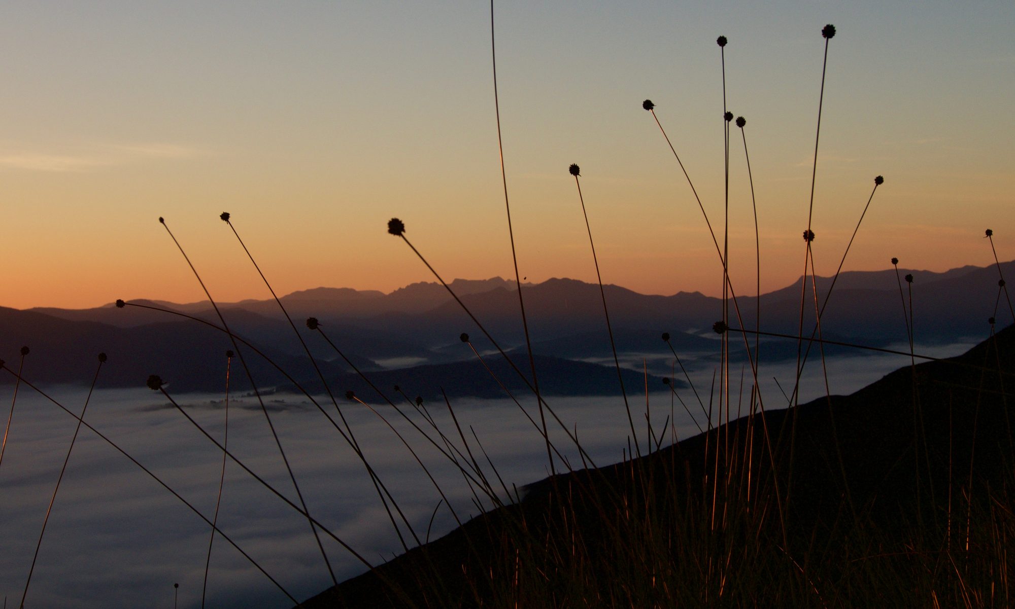
This time, by the time we made the ridge (1:10 hrs after having started, with a little bit of phaffing), we couldn’t see anything but button grass stalks silhouetted against the white mist. I was a bit disappointed, mostly because I knew what COULD be seen, and had hoped Graham might get to see it. Though, as my mother and sister quickly made me realise with a comment on a photo I posted on Facebook, the button grass itself was ‘magic’ and ‘awesome’. Sometimes it pays to wipe clean one’s expectations, wants and desires, and just accept and appreciate the gifts that are.. hmmm.. need to practice that a lot more!

After spending a bit of time getting our heads around going right to head left along the ridge, the weather started to open up a bit, and we were treated to a most interesting spectacle. The mist and cloud that completely wiped out any view to the north/east came up, hit the side of the range, and went straight up, but not over. It was like there was an invisible line or glass wall that stopped it from travelling further, and it meant that our views out to the south/west were relatively open (save for the low cloud). Quite amazing, to be walking along the vertical ‘mist line’. I remember seeing and walking into a horizontal mist/cloud line coming down off Ossa, and finding that most exciting, this was kind of the same!

Every now and again the mist would clear, and we’d get hints of the view out to Lake Gordon, or a vague outline of Mt Wedge in behind mist. Patches of sun on the flanks of the Coronets also teased us as we shivered in our rain jackets and tried to find a balance between keeping fingers but needing to bare them to the elements as we attempted to capture some of the experience with our cameras.

The clamber back down the ridge was even more fun (down always is, especially on overgrown tracks), and we started to warm up the further down we went (also had less photo stops).

Back at the river crossing, the flow of water had subsided a bit, though was still running OVER the log bridge (compare the two photos). Graham jokingly instructed me to take a photo of him falling in. I did try.. but he didn’t keep up his part of the bargain! We decided on lunch in the car at the lookout near the Needles, and spent time chatting about the Thumbs (our view) and other walks as we ate.

It was shortly after 2 by this stage, and the rally was clearly over as cars whizzed by. The wilderness was suddenly not so wild. Many stopped to take a photo or two of the view back out over the Florentine valley. Quite a number decided to also climb the Needles before heading home.

The Needles track is marked with a cairn on the side of the road, and the old faded pink tapes have been reinforced with newer pale green ones, directing you to the logbook. From there it’s another steady climb, not quite as steep as the Sentinels perhaps, but steady all the same.

When we heard and saw someone coming up behind us Graham put the foot to the accelerator and it suddenly felt a lot steeper! I was beginning to wonder whether I’d be able to keep up with him all the way to the summit, which was in sight and really not far off, but seemed an impossibly long way off all the same. But as if to read my mind (and maybe he was feeling just a bit tired too, or wanted a photograph – the more likely scenario), he stepped off to one side, and I followed suit, gratefully gasping for air. A hello, and brief exchange was made, before I was instructed to go and stand on a rocky outcrop.. yes, apparently it was a photo calling, not tiredness! The modelling over, we continued the last little climb at a more agreeable pace.

We popped out on top to find five others up there, pleasantly surprised to realise that we’d met two the week before at Scott Kilvert Hut! And then a third recognised me from Lightening ridge from a trip out that way in autumn last year! Had more of a chat to yet another who knew one of the reps I knew from my old job, and then, as always, the conversation turned to mountains. Amazing the coincidences and the people you meet out walking :)!!

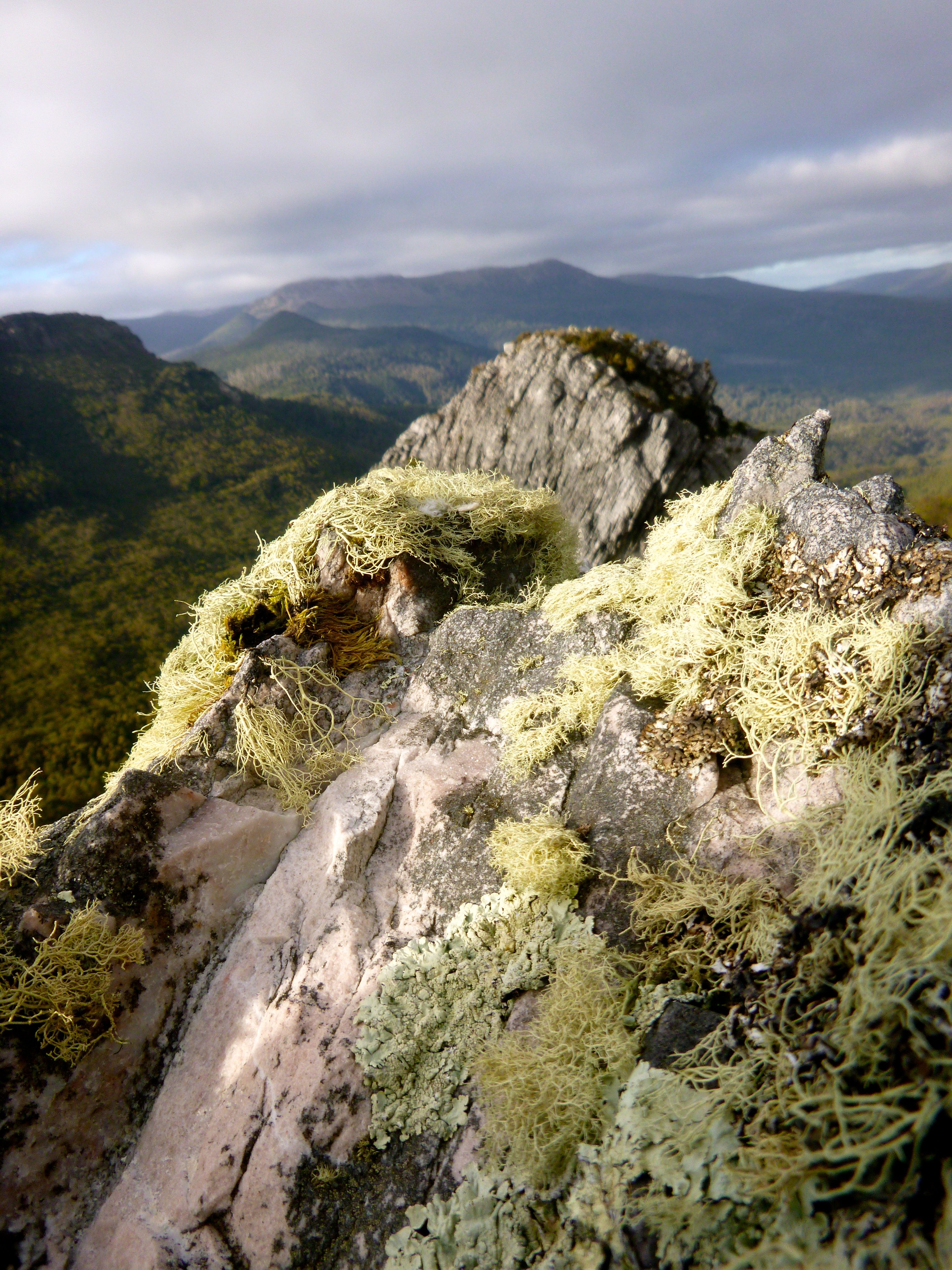
They headed back down, and we followed suit. We got distracted part way down, by some lovely rocky play equipment. I’d looked at it on the way up, but hadn’t given it much more than a look and wishful thought. When Graham stopped and looked at one, sufficiently steep but possibly climbable one, a great big smile broke out on my face and an excited, and slightly disbelieving, ‘really??!’ was asked. Yep, why not?! AWESOME!!! 😀 Usually on walks I have to be sensible, or there’s not time, or I’m alone and it’s not fun to do that kind of thing alone because there’s no one to take a photo, or to share the excitement and challenge with.. so this made my day.

Up we went, can’t go right.. let’s try left.. yep, it’s a goer.. and there we were, on a rocky lichen decorated top, laughing at our madness. I was instructed again to wait, while Graham climbed back down and took a photo or three. I didn’t mind, I had a bit of fun conversing with the lichen, and having one of those moments where everything feels like maybe it’s going to be ok after all.

Back on the track, and a bit more down to go, we passed a few others making the climb up. I discovered money sometimes does grow on trees (well button grass clumps) and picked up a $5 note off the side of the track. It went with the watch Graham had found on the way up the Sentinels (incidentally, if anyone lost a watch climbing the Sentinels or knows someone who did, do be in touch).

A surprisingly quick 2 hours after having started (surprising given the amount of talking, and mucking around on rock that we did), we were back at the car. Back home shortly after 6, that’s got to be the shortest day walk I’ve been on for a while! From feeling sick, tired and flat, I’m reenergised, and very grateful to have been able to get out for a fun walk. Thank you Graham, and for driving too.

All up:
Sentinel range: 4.5km, 3:50 hrs (lots of phaffing around), 685m ascent.
Needles: 3.3km, 2 hours, 400m ascent.


I had my first visit to the Needles this week and loved it. I need to go back. The Sentinels caught my eye further along the road and as a non-bushwalker, they have really captured my imagination and I know that I have to go up there now that I’ve read this post and know that it’s possible to do it. I’m guessing that as a relatively inexperienced hiker, it wouldn’t be a good idea to attempt this on my own?
LikeLike
Hello 😃!! Your words remind me of the first walk I went on, to Scott’s Peak. I remember sitting on top, looking at the mountains around and their mirror images reflected in Lake Pedder. They drew me in and I knew I’d be visiting them… and each time I go, there’s at least another mountain that beckons!
As for walking alone, I’d usually say it’s best to go with someone else when I don’t know the person I’m talking to. However, there’s exception to that, depending on how you feel about walking alone, and the conditions you choose to walk in. I went on my first solo walk fairly early on, and found it a really rewarding experience where I learnt a lot about myself – mostly from the mistakes I made! The Sentinels is a great mountain for a solo walk in good weather. It’s on a busy enough road if you break down you’ll have help soon enough. It’s not overly ambitious as a day walk. It’s got a pretty good track – I took my brother and his partner up there and they’d never been bushwalking before, and despite the fact they complained that it was off track the whole time, they were able to stay on the track while leading without my help. It’s got a good safety net – if you do lose the track in a worst case scenario, you can straight line for the road. The biggest risk, which is true for all solo walks, is if you seriously injured yourself and were immobile without phone reception. You could borrow an epirb or plb for this.
The only slightly difficult part to the walk is if you end up with cloud as you crest the ridge, it can be easy to go the wrong way. If you’re ever unsure, you can use a gps, or just take time to check you are on the track and not an offshoot, and be prepared to back track if not. It’s hard being solo to back youself if not sure, but generally your instinct is right!! And worst case, if you can’t figure it out, there’s always another day!!
It’s a different experience entirely, but I suspect you’d like it!
LikeLiked by 1 person